
By: Rashmit Singh Sukhmani, Co-Founder and CTO at SatSure
Over the past decade, our ability to observe the planet has changed dramatically.
Satellite constellations have expanded, revisit times have improved, sensors have become more diverse, and Earth Observation data is more accessible than ever before. That should have made reliable Earth intelligence easier to build. Instead, it has revealed that much of the real difficulty begins after the data arrives:
- Different signals must be reconciled and ground truth must be established.
- Models need to be developed, validated and kept reliable as conditions change.
- Their output must then reach the right stakeholder, at the right time and at the right geographic level, and
- With enough context to be trusted and acted upon.
Some of these challenges come from the nature of the Earth itself. Others emerge when organisations try to turn that complexity into products and operational systems. Together, they create a challenge that extends far beyond imagery or model accuracy.
The next frontier of geospatial AI is about building Earth intelligence that remains useful as the world changes, and becomes easier, not harder, to extend over time.
More Data Was Never the Solution
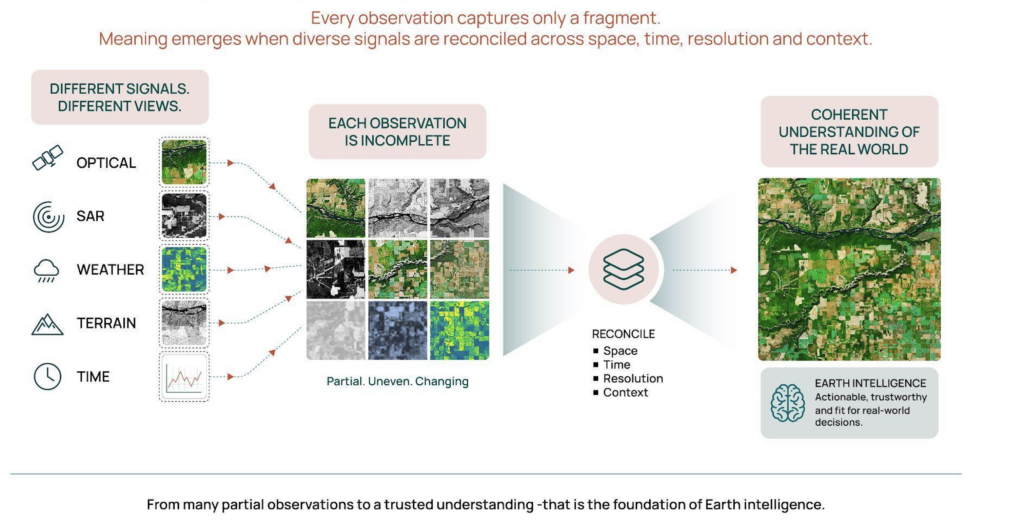
Every observation captures only a fragment of a much larger system. And it’s value depends on a plethora of factors, such as, what appears in the image, where it appears, when it was observed, what surrounds it, and what happened there before.
Earth intelligence is inherently spatial, temporal and multimodal. The same visual pattern can mean different things in different locations, while a single image may reveal very little without the history of change across days, seasons or years. Optical imagery, synthetic aperture radar, weather, terrain, soil, and administrative data each capture a different part of the same physical reality.
Before meaningful learning can begin, these signals must be aligned across space, time, resolution, and context. Even then,
- clouds obscure optical imagery,
- revisit cycles leave gaps, and
- sensors behave differently under different conditions.
A change on the ground may occur between observations, and by the time the next imagery set arrives, the landscape may already have moved on.
The planet is constantly rewriting itself.
This is what makes Earth Observation fundamentally different from a conventional prediction problem. The challenge is to build a coherent understanding from observations that are partial, uneven and continually changing.
And the uncertainty does not stay inside the data. It travels downstream to the real-life applications of this data!
Complexity Travels Through the Entire Lifecycle
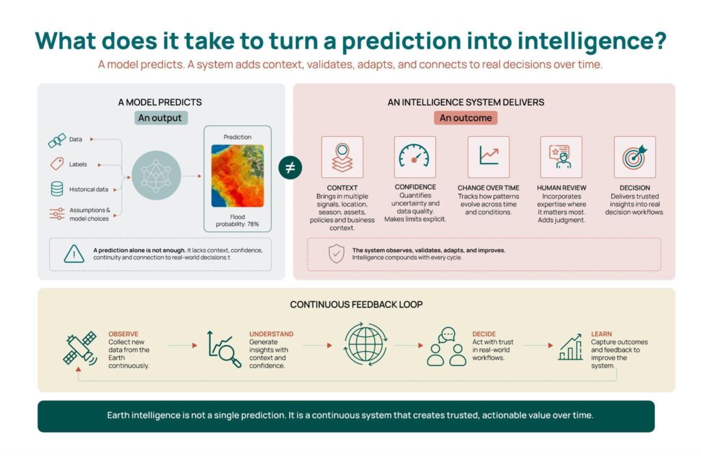
Operational Earth intelligence is more than a modelling exercise. It is a long chain of interconnected steps: discovering and preparing data, reconciling observations, creating and validating labels, developing and testing models, validating them across changing conditions, deploying and monitoring them, and ultimately delivering the result within a real decision process. What begins as uncertainty in an observation can become friction throughout the entire process of producing intelligence.
Consider three applications that appear very different:
- Detecting features around critical infrastructure,
- Classifying crops, and
- Identifying tree species.
Each requires its own domain knowledge and definition of success. Infrastructure intelligence may depend on recognising small physical features at high resolution. Crop classification relies on field boundaries and patterns that unfold across a growing season. Tree-species identification may require fine-grained spectral differences, canopy structure and reliable field observations.
Yet beneath these differences, the teams building these solutions encounter many of the same challenges. They must reconcile data across sensors, resolutions, locations and time; create dependable labels; learn recurring patterns of vegetation, boundaries, structures and change; validate performance under new conditions; and deliver output in a form that can support real-world decisions.
Today, much of this work is repeated across separate pipelines. What one application learns rarely becomes directly available to the next. The applications are specialised but the underlying intelligence does not accumulate at the same rate.
A highly accurate output that arrives after the decision window has closed has limited value. So does an alert that cannot be linked to the right asset or geography, or one that gives the user no way to understand its confidence. Earth intelligence is not the output of a model. It is the outcome of the entire lifecycle working together.
The Way the Industry Builds Today
The current approach to geospatial AI did not emerge by accident. Crop classification, flood intelligence, infrastructure monitoring, forestry and climate-risk applications each have distinct data requirements, operating conditions and definitions of success. Building dedicated pipelines for dedicated problems was logical and necessary, and it has enabled much of the industry’s progress.
The difficulty becomes apparent when this project-level success is viewed at the level of the system.
A new application often follows a familiar sequence: identify the relevant data, create labels, engineer a model, validate it for the intended conditions, deploy it, connect it to a customer workflow and maintain it over time. The pipeline may work extremely well, yet much of the knowledge created within it remains confined to that application.
When the next geography, customer or use case appears, large parts of the process begin again. Data must be reconciled, labels revisited, models adapted and output revalidated. Production and delivery systems must once again be configured around a new set of requirements.
The industry has become very good at building successful geospatial solutions. The harder question is whether every new solution makes the next one meaningfully easier to build.
Too often, it does not.
The Current Paradigm Hits a Limit. Quickly.
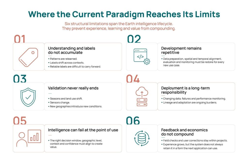
The limitations are no longer confined to model accuracy. They appear across the entire Earth intelligence lifecycle — from understanding and labelling the world to developing, validating, deploying, and ultimately delivering intelligence that can be trusted and acted upon.
1. Understanding and labels do not accumulate
Different applications repeatedly encounter the same underlying Earth patterns—water, vegetation, built structures, seasonal behaviour and signs of disturbance. Yet these patterns are often relearned within separate datasets and pipelines. Reliable labels are equally difficult to carry forward, as their meaning can shift across geography, season, sensor and application.
2. Development remains repetitive
Many applications share the same foundations: data preparation, spatial and temporal alignment, evaluation and monitoring. Yet substantial parts of these workflows are rebuilt for every new application. Experience grows, but the system does not always retain it in a form the next application can use.
3. Validation never really ends
Earth keeps changing. Seasons shift, land use evolves, sensors change and new geographies introduce conditions that may not have existed in the original training data. Validation therefore cannot end at deployment. It must continuously establish where the system can be trusted, where it should be questioned and when its behaviour has changed.
4. Deployment becomes a long-term responsibility
Building the model is only the beginning. Production systems must ingest changing data, manage failures, monitor performance, preserve lineage and adapt as regions and customer requirements evolve. As independent deployments multiply, so does the operational and governance burden of maintaining them.
5. Intelligence can fail at the point of use
End users are rarely looking for another model. They need intelligence that helps them make a decision. It must arrive within the relevant decision window, at the right geographic level and with enough context to understand what happened, how confident the system is and what requires attention.
6. Feedback and economics do not compound
Every deployment generates valuable feedback—from field checks and user corrections to missed events. And that learning often remains trapped within individual projects. The economics of Earth Intelligence often follow the same pattern: when every application requires fresh data preparation, labelling, engineering, validation, deployment and integration, growth continues to depend on adding project effort rather than building reusable capability. The problem is not that task-specific systems fail. Many work extremely well. The problem is that their success does not naturally strengthen the system as a whole.
From Successful EO Models to Stronger Intelligence Systems
Specialised models of course remain essential, and necessary, because different decisions require different kinds of intelligence. The opportunity therefore lies in:
- Moving from systems that solve problems independently to systems that become more capable with every problem they solve.
- Not simply building another successful model, but creating intelligence that accumulates understanding across its lifecycle.
So, can a new application inherit what the system has already learned rather than begin from scratch? And can every deployment make the next one more capable?
That is the journey this series explores.
In the next article, we begin with the idea at the centre of this shift: reusable intelligence — not as a promise of one model for every problem, but as a way for understanding to become an asset that compounds across tasks, domains and time.